Category Archives: redistricting

New County Council District Maps

This post is a collection of the new councilmanic district maps from around Maryland. It is an updated version of one of the most popular posts on Seventh State with the 2010s maps. I have done my best to make sure that they are the new rather the old districts. I have been unable to locate the new Baltimore City, Garrett County, and Talbot County Council maps.

If you know where I can find them or if any of the maps here are incorrect, please let me know. It’s often hard to be completely sure which proposed maps have been adopted. Additionally, some of the new maps are exceedingly similar to the old ones. My hope is to put up a complete and corrected post in the future.

The maps here are organized by the type of electoral system used by the county starting with (1) elected at-large with district residency requirements followed by (2) elected entirely from districts, and (3) elected by a mixture of districts and at-large. Counties are listed alphabetically within each category.

Allegany, Caroline, Kent and Washington Counties elect their entire county commissions at large.

ALL ELECTED AT-LARGE WITH A RESIDENCY REQUIREMENT

Calvert County: Five commissioners with two with no residency requirement and three from districts.

Charles County: Five commissioners. There is no residency requirement for the commission president with four additional commissioners elected from districts.

Cecil County: Five commissioners with staggered terms.

Any changes from the previous map appear very small.

Garrett: Three commissioners. No map available.

Queen Anne’s: Five commissioners. There is no residency requirement for one commissioner with four additional commissioners elected from districts.

St. Mary’s: Five commissioners. There is no residency requirement for the commission president with four additional commissioners elected from districts.

Talbot: Five councilmembers. No map available.

ALL ELECTED FROM DISTRICTS

Anne Arundel: Seven councilmembers.

Baltimore County: Seven councilmembers.

This map was the subject of voting rights litigation over the county’s failure to create a second majority-black district.

Carroll County: five commissioners.

Dorchester County: five councilmembers.

The changes from the previous map, if any, appear small.

Howard County: five councilmembers.

Prince George’s: nine councilmembers.

Somerset County: five commissioners.

Worcester County: seven commissioners.

Any changes appear very small. Please let me know if this is not the current map for the county.

MIXED

Baltimore City: 15 councilmembers with 14 elected from districts and the council president at-large. No map available.

Frederick County: five councilmembers elected from districts and two elected at-large.

Harford County: six councilmembers elected from districts and the council president elected at-large.

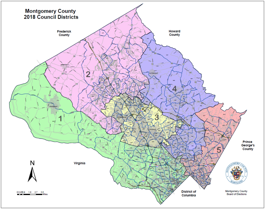
Montgomery County: seven councilmembers elected from districts and four elected at-large.

This map adds two new districts over the previous version, increasing the size of the council from nine to eleven.

Wicomico County: five councilmembers elected from districts and two elected at-large.

Share

Baltimore County Proposes New Council District Map: Is It Voting Rights Act Compliant?

Baltimore County’s Proposed New Map

In the wake of a federal court granting an injunction against the new map for Baltimore County Council districts due to likely Voting Rights Act violations, Maryland Matters reports that Baltimore County has submitted a new map to the federal court.

The new map still contains only one majority Black district (District 4). However, District 2 has been altered to increase its Black population from 29.6% to 41.2%. Whites no longer form a majority but still are a plurality of 45.8% in the new version of District 2.

Despite Whites outnumbering Blacks in the new District 2, it may satisfy the requirements of Section 2 of the Voting Rights Act and provide Black voters a meaningful opportunity to elect the candidate of their choice. The federal court will have to assess whether that’s the case.

As Blacks tend to participate at a higher rate than Whites in Democratic primaries, Blacks may form a majority in the Democratic primary despite being only 41.2% of the population. If the Black-preferred candidate receives sufficiently high Black support (or additionally gains enough non-Black support), the candidate can win the primary.

In the general election, the Black-preferred Democratic nominee can win as long as enough Black voters support the candidate and sufficient numbers of non-Black, mostly White, voters also vote for the candidate. If enough Whites vote as a bloc for the Republican, the Black candidate could still lose, particularly if White turnout exceeds Black turnout.

These questions about voting behavior are not matters of pure speculation but can be examined. However, the plaintiffs in the lawsuit complained in a brief filed yesterday that Baltimore County had, as of the evening of March 7th, “withheld the data necessary to assess whether the map complies with the Court’s order.” (See the brief embedded below or click on this link.)

Baltimore County should provide the analyses needed to assess the ability to elect in order to show compliance with the court’s order. They should also make available the data to the plaintiffs so that they can conduct their own separate analyses, especially since the answers to these questions are not clear.

Share

MD State Redistricting: Where Will Be Over or Underrepresented?

Data calculated by author.

The General Assembly is moving forward with the redistricting plan recommended by the Legislative Redistricting Advisory Commission.

Redistricting in America emphasizes population equality very heavily. Congressional plans have been overturned by federal courts for unjustified deviations from population equality of as little of 20 people. Many states adopt plans in which the most populous district has only one more person than the least populous district to insulate them from challenges on these grounds.

The federal courts have usually given state legislative plans more wiggle room, though they have not always deferred to jurisdictions that meet a standard of having deviations less than 5 percent above or below the ideal population, or 10 percent total.

The Maryland plan meets the 10 percent standard but the cumulative impact of variations in legislative district size across multiple districts within some jurisdictions may raise eyebrows. Some counties are noticeably over or underrepresented compared to others.

The table at the top of this post shows the legislative district (LD) entitlement of various jurisdictions based on population. Each LD elects one senator and three delegates with some divided into two or three subdistricts for purposes of delegate elections.

The table further reveals the how many LDs were allocated to jurisdictions along with the difference from their entitlement based on population. The final column shows the same information in terms of the number of delegates, which is just three times larger than for the entire LD. Where a proposed subdistrict or district spans a county line, I allotted the representation from the district based on population.

Most areas are quite close to their population entitlement, but a few areas stand out as winners and losers. Together Baltimore City and County have nearly an entire delegate more than they are entitled to based on population. Baltimore City has 55% of a delegate more than entitled to based on population while neighboring Baltimore County has 44% more.

Meanwhile, Prince George’s has 70% less of a delegate than it merits based on population. Prince George’s together with the three southern Maryland counties of Charles, Calvert and St. Mary’s together merit an additional delegate based on population. The Eastern Shore as a whole is also down 28% of a delegate.

Perhaps it is not coincidental that House Speaker Adrienne Jones lives in Baltimore County and the Senate President Bill Ferguson lives in Baltimore City. It is also part of a history of Democrats trying to protect Baltimore City from its long-term population decline.

The City of Baltimore had 11 LDs in 1974 but will be down to 4 2/3 if this plan goes into effect for 2022. Past efforts to preserve City influence by extending existing City districts into Baltimore County led to the Maryland Court of Appeals overturning the 2001 map for General Assembly districts.

Share

Does the Frederick Donut Violate the Constitution?

Proposed Frederick County Legislative Districts

Maryland Matters reports that one Republican legislator has raised questions regarding whether the legislative districts proposed for Frederick County would pass constitutional muster:

Del. Jason C. Buckel (R-Allegany), the House minority leader and a member of the Legislative Redistricting Advisory Commission, questioned whether the new proposed District 4 would pass muster for compactness. The proposed District 4 would encompass much of Frederick County around the city of Frederick, which is contained within District 3, creating what Buckel described as a “donut effect.”

Del. Buckel is almost certainly wrong. The donut does not exist in spite of the Maryland Constitution but to comply with it. Ironically, this is for the same reason that I expressed concern in yesterday’s post about whether District 17 can survive a constitutional challenge: the requirement of “due regard” for “the boundaries of political subdivisions.”

This same provision indicates that the City of Frederick ought to be kept in a single legislative district if possible unless it conflicts with other requirements. At this point, the population of the City and its surrounding suburbs is sufficiently high as to easily meet the population for a legislative district, resulting in a more compact shape than the existing plan in which District 3 extends to the Virginia border.

Putting most of the rest of Frederick County into a surrounding legislative district is the logical consequence of same provision requiring “due regard” of administrative divsions as it avoids unnecessarily extending District 4 into another county.

Del. Buckel’s point reflects that the Maryland Constitution also says that legislative districts should “be compact in form.” But it’s not clear that extending District 3 to the Montgomery County line would improve the compactness of either Districts 3 or 4. It might lengthen the perimeters of both Districts 3 and 4 and reduce compactness according to measures that have been commonly used in past redistricting litigation. One would have to look to be sure either way but I doubt it would be nearly enough to cause a court to second guess the legislature’s approach.

Bear in mind also that District 3 is not an independent enclave trapped by its neighbor. It’s not Lesotho. Enclosing District 3 in District 4 doesn’t make it impossible to leave District 3 without a passport. The City of Frederick isn’t being deprived of a seaport.

Others might wonder about why a bit of District 2 extends into Frederick County.

Proposed Western Maryland Legislative Districts

That’s easily explainable by the State’s geography and population changes. District 1 must start in Garrett County, take in all of Allegany County and then the western part of Washington County to pick up enough population.

Currently, District 2 neatly comprises the remainder of Washington County with the Washington-Frederick border serving as its eastern boundary. That’s no longer possible. The western three counties continue to lose population relative to the rest of the state, so the districts encompassing them move east with each redistricting cycle. At this point, they must extend into Frederick.

The good news is that Frederick has grown sufficiently that the ripple effect stops there. Unlike under the existing plan, none of the proposed districts traverse Frederick’s border with Carroll County.

Share

Does the Gaither-Split Violate the Constitution?

Where the Proposed Legislative Map Divides Gaithersburg

The portion of the Legislative Redistricting Plan for Montgomery County takes a status quo approach. However, it still might violate the Maryland Constitution.

What’s Not a Problem

The major change from the current arrangement is that district 9A, centered in Howard County, now takes in a portion of northern Montgomery County around Damascus. This inclusion of a portion of a ninth (!) legislative district reflects Montgomery’s growth.

It also not so coincidentally happens to aid Democratic Sen. Katie Fry Hester who exchanges a bit of very Republican Carroll County for this bit of Montgomery County. Damascus may be among the more Republican areas of Montgomery, but it is probably friendlier turf for her than the portion of Carroll she lost.

None of this should pose a problem for the plan.

What is a Problem

Instead, the potential problem centers on the new version of District 17. When drawn after the 2010 Census, the district included all of Rockville and Gaithersburg. The new version doesn’t. The dark black lines on the above map show my rough look at where the proposed legislative district boundaries cut into the City of Gaithersburg.

Over the past decade, Gaithersburg annexed areas around Quince Orchard and Shady Grove North that are not in the new D17. Larger areas of northeast Gaithersburg just west of Washington Grove are also outside D17. Most of the excised portions are in D39 but the Shady Grove North bit is in D19.

This invites a constitutional challenge because Article III, Section 4 of the Maryland Constitution states that that legislative district boundaries must give “due regard” to “the boundaries of political subdivisions.”

The Maryland Court of Appeals gave life to this provision when it invalidated the 2001 map, in part for violating too many boundaries. In particular, more districts straddled the Baltimore City and County boundary than necessary.

The Court made clear the importance of this requirement in its decision, writing: “Non-compliance with a state constitutional requirement is permitted only when it conflicts with a federal requirement or another more important Maryland constitutional requirement.”

The State might argue that hiving off part of Gaithersburg was needed so that the district was not overpopulated. But this feels like a dud. After all, the state could have just split Rockville and Gaithersburg into separate districts that included all of each municipality.

The Legislature has a couple of options short of completely redrawing the plan. First, it could redraw the map to include the currently excluded parts of Gaithersburg. Except that this change might well make the district exceed the acceptable population deviation of +/- 5%. The district is already 2.5% larger than ideal.

If this doesn’t make D17 too large, it would solve the problem and make it difficult to challenge the map on this basis. My guess is that the district would end up overpopulated, as the line drawers would otherwise have done this in the first place.

If it does make it too large, the State could try to justify the deviation as desirable to adhere to municipal boundaries. But this faces the same problem as the proposed map in that one could have just put the two big municipalities into separate districts instead.

The State could roll the dice with the proposed map as it stands. Beyond explaining that the portions sliced off Gaithersburg are small and partially not in the current districts, the State could argue that this change was needed to preserve the cores of current districts. The Special Master argued that this was one reason that the 1992 Plan, which was upheld by the Court, did not violate the Maryland Constitution.

This argument seems unlikely to fly, however, because the Court of Appeals explicitly rejected it in 2001, stating: “The premise on which the Special Master proceeded, that the due regard requirement may be subordinated to achieve a ‘rational goal,’ and the State’s argument that the provision must give way to ‘more important considerations,’ also are wrong.”

The Court goes out of its way to make clear that this provision of the Maryland Constitution limits the state’s power even though the “due regard” provision is less strongly worded than similar provisions in other states. In short, it’s there for good reason, such as limiting partisan gerrymandering, and the State cannot ride roughshod over it.

The Court might still uphold it as a de minimis (i.e. trivial) violation of the provision. It could also rule that violations of municipal boundaries are less serious than the violations of county boundaries. Baltimore City is unusual in that it is the only municipality that is also a county equivalent, so the Court could distinguish these questions about due regard for political boundaries from those at issue in its 2001 decision.

Still, it’ll make the inevitable legal challenge to the Legislative Redistricting Plan a lot more interesting if this remains in the final plan. As in 2001, a victory for plan opponents could result in a court-drawn plan because time is short before the primary.

Share

Did Baltimore County Violate the Voting Rights Act? My Guess is Yes.

Baltimore County approved its new councilmanic district map on Monday. Here it is:


And here are the existing districts:

The ACLU of Maryland tweeted that it plans to file a lawsuit challenging the new plan under the Voting Rights Act (VRA). The Baltimore NAACP has already done so. Do they have a case? My educated guess is yes, though one would need to a more thorough analysis of the jurisdiction to be sure and to gather evidence needed for a successful VRA lawsuit.

The Supreme Court established a three-prong test in Thornburg v. Gingles (1986) that still sets the key conditions for proving a violation of Section 2 of the VRA.

First, plaintiffs need to prove that you could draw a “sufficiently large and geographically compact to constitute a majority in a single-member district.” The Baltimore Sun reports that map opponents have already shown that either the First or Second Districts, which are around 30% Black, could be converted into a Black majority district. The Fourth District is 72% Black; it could shed several predominantly Black communities and remain majority Black.

Second, plaintiffs must show that the minority group is “politically cohesive,” which just means that they need to show that Blacks in Baltimore County tend to vote together. This can usually be easily shown through analysis of election returns.

Third, and most crucially, plaintiffs must show that racial bloc voting usually defeats the minority group’s preferred candidate, usually referred to as a “candidate of choice.” Preferred candidates are those who win the vote in the Black community with candidates of the same race considered most probative evidence in a VRA lawsuit. However, non-Black candidates who defeat a Black candidate with the support of Black voters are also considered useful to examine for the purposes of a lawsuit.

In Baltimore County, no Black candidate has been elected to the Council except from the sole majority Black district. In the last state legislative elections, two Black state senators won in Baltimore County—both in majority Black districts. Four Black delegates also won election from majority Black districts. Excluding the district that is mostly in Howard County, the only Black Baltimore County state legislator who represents a non-Black majority district is Del. Carl Jackson but he was appointed in 2019, not elected.

Again, one would need to look more closely and further back to do a proper analysis, but all Black councilmembers and state legislators elected in 2018 won in Black majority districts (excluding Del. Terri Hill who represents the district predominantly in Howard).

In a lawsuit, Baltimore County might well argue that the new version of the First District is a second majority-minority district. In order to win on this basis, the defendants would need to show that the First District provides meaningful opportunity to elect the Black community’s preferred candidate. While it lacks a White majority, Whites form a strong plurality.

Even if plaintiffs win a VRA lawsuit, Baltimore County might not need to draw a second new Black majority district. Just because you need to show that you can draw a Black-majority district to bring a Section 2 lawsuit doesn’t mean that a new Black-majority district must be drawn to satisfy the VRA.

The standard is whether the district provides a meaningful opportunity to elect the minority’s preferred candidate. Since Black voters cast ballots disproportionately in the Democratic primary, they often comprise a majority of Democratic primary voters even when they do not in the voting-age population. This can allow a Black candidate to win the primary even without any White support.

If a Black candidate supported by the Black community can win the Democratic nomination in such a district, and the district is sufficiently Democratic that the nominee would win the general election, that district would still satisfy the VRA even though it is not a Black-majority district.

[Sidenote: If most Blacks voted for a Republican, then the Republican candidate would be the minority preferred candidate. I refer to the Democrats here because the reality is that the Democratic Party usually gets the great majority of the Black vote in Baltimore County and Maryland. But it’s all about the preferences of the voters.]

So why didn’t Baltimore County draw a second district that provides an opportunity for Black voters to elect their preferred candidate? That’s a story for another day.

Share

Assembly Democrats Shoot and Miss

The new Democratic congressional map is political malpractice in the first degree.

Both parties have aggressively pursued gerrymanders this year—Democrats in New Mexico, New York and Illinois—Republicans in North Carolina, Ohio, Texas and Wisconsin—to take a few examples. The critical difference, however, is that the Democrats have proposed a national ban on gerrymandering, while Republicans remain adamantly opposed.

Gov. Larry Hogan has lambasted creative Democratic line drawing in Maryland, where such attitude benefits his party, but is hardly an avatar of reform. He has studiously avoided commenting negatively about Republican gerrymanders elsewhere or endorsing national legislation to address the problem.

Good government promoters along with newspapers like the Washington Post and New York Times piously inveigh against gerrymandering by either party. Except at this point, given the unashamed efforts by Republicans to gerrymander wherever they can—and fighting national efforts to ban it—Democrats choosing to abandon it is unilateral disarmament. The distribution of Democrats already works to the benefit of Republicans, but Republican gerrymandering is designed to assure partisan lockups by the GOP whether the voters agree. This is already the case in the Wisconsin legislature.

Which brings me to Maryland.

General Assembly Democrats decided to reconfigure the districts to render the First District a toss up (at best) for their party rather than a safe Democratic seat. Some of the potential reasons were outlined in a piece appearing in Slate:

[Rep. John] Sarbanes is also the lead sponsor of the For the People Act, or H.R. 1, which includes as a central plank an end to partisan gerrymandering and a national move to independent, nonpartisan redistricting commissions. As a national crusader against gerrymandering, he couldn’t bring himself to go full 8–0, several Democratic sources said. . .

[Rep. Kweisi] Mfume was concerned that absorbing chunks of largely white Republican voters into his district from Harris’ would distract from his representation of majority-minority communities in Baltimore. He was adamant against suggested changes, like stretching his district north to the Pennsylvania border. . .

[The Maryland Legislative Redistricting Commission] settled on the seven-Democrat map with a more competitive 1st District. This one still extended Harris’ district across the bay to Anne Arundel County—but curiously excised Annapolis, the inclusion of which would have been quite helpful to the Democratic candidate challenging Harris. Several sources cited one factor: The Democratic state senator representing Annapolis, Sarah Elfreth, didn’t want a competitive congressional district like the 1st layered atop hers. (“Sen. Elfreth had no role,” her staff told me when asked about this factor.)

In contrast, Reps. Steny Hoyer and Jamie Raskin were described as fully on board with an 8-0 map.

In the end, General Assembly Democrats settled on a map that is truly the worst of all worlds. They drew a district that has an excellent chance of reelecting Rep. Andy Harris—an ivermectin prescribing, coup friendly representative. Yet the lines are sufficiently ugly that no one is going to give them “credit” for not gerrymandering. Is Rep. Sarbanes really so benighted that he thinks he looks good because he stopped Democrats from gerrymandering more?

Indeed, the map preserves some of the old plan’s more derisory elements, such as the Hoyer hook that swings the Fourth into College Park completely unnecessarily. And Third District Rep. John Sarbanes will represent Harford and Montgomery Counties.

To those who say it is unfair to have an 8-0 map, let them get a national gerrymandering ban passed. It’s a great overdue idea that’s languishing due only to Republican opposition.

In the meantime, an 8D-0R map in Maryland, where Biden won 65-32 seems a lot fairer than the projected 11R-3D map in 50-49 (Trump) North Carolina, 9R-5D map in 50-49 (Biden) Georgia, or 12R-3D map in 53-45 (Trump) Ohio. Republicans also seem unbothered by the Democratic shutout in Oklahoma, which Trump by the same margin as Biden won Maryland.

Meanwhile, the maladroit gerrymander passed by General Assembly Democrats no doubt has many people rolling their eyes either because it’s a gerrymander or because it’s such an incompetent one. SMH.

Share

Top Seventh State Stories, December 2020

By Adam Pagnucco.

These were the top stories on Seventh State in December ranked by page views.

1. What Happened to White Flint?
2. The Day of Reckoning is Near
3. Jawando Calls for a Tax Hike
4. Come on Now
5. Who’s the Boss?
6. MCEA to School Board: Reopening Should be Safe
7. Trump vs Hogan: Votes by MoCo Town
8. Council Overrides Veto, Attacks Elrich, Cuts Revenue for School Buildings
9 (tie). Minority Members of the U.S. House
9 (tie). Corporate MoCo Council Adopts Supply-Side Economics

The top three stories fit together and have meaning for the new year and beyond. The Day of Reckoning is Near summarizes the county’s dire fiscal picture as it heads into a challenging FY22 budget discussion in the spring. Jawando Calls for a Tax Hike kicks off an inevitable dialogue about taxes, one which will only get hotter before the executive makes his budget recommendation on March 15. And What Happened to White Flint? – December’s runaway winner – lays out the story of how the county’s premier development plan has been held back by our slow rate of job growth. Budget headaches, taxes and economic problems are about to collide.

Welcome to 2021, folks!

Share

Come On Now

By Adam Pagnucco.

MoCo is about to embark on one of its most important tasks of the decade: redrawing county council districts. The county’s charter mandates redistricting every ten years in line with the release of new U.S. Census data. The charter also states that the council must pick a redistricting commission to recommend new boundary lines (although the council retains the final say). The current redistricting will be particularly intense given the recent passage of Question C, which expanded the number of districts from five to seven.

MoCo’s current county council districts.

More than 100 people applied to be on the 11-member redistricting commission and 32 were scheduled for interviews. The interviewed applicants include:

1. Two former elected officials, including one who used to be a council member and has run for two different offices in the last five years.

2. Five other former candidates for office, including one who has run for office seven times since 2009. Three of these former candidates have run at least once since 2018.

3. Two political consultants, one of whom has worked for MoCo politicians, including sitting council members.

4. Two spouses of sitting municipal elected officials. Both of these officials unsuccessfully ran for higher office before being elected to their current positions. One of the spouses also ran for office, including for council in 2017-18.

5. A sibling of a 2018 council candidate who has managed multiple local political campaigns.

These are not bad people. To the contrary, most – if not all – of them have done good things and can serve the county well in other roles. But the redistricting commission is a critical body that will play a key role in designing council districts for the next decade. The importance of this exercise to county residents cannot be overstated. The public interest should be the sole determinant of redistricting. Given the fact that the public is watching how this plays out:

It would be wise to avoid the appearance of a candidate designing his or her own district for a future run.

It would be wise to avoid the appearance of a political operative designing a district for a client.

It would be wise to avoid the appearance of a commission member designing a district for a family member.

Redistricting is an official and supremely important act of county government but it’s also a very sensitive one. Many people are jaded about “gerrymandering” and the county just had an all-out ballot war over the appropriate number of council districts. I can’t count how many times I have seen the word “machine” used to describe the county’s politics this year. In this climate, it won’t take much to get people to believe the worst about redistricting, and given the recent popularity of charter amendments, who knows how far such sentiment could go.

There are plenty of qualified applicants who could do a good job and don’t have any of the above issues. Come on now, council members! Please consider them when choosing who serves on the redistricting commission.

Share

Redistricting’s Biggest Losers

The current crop of state legislators is just one year into their current term. But after next year’s session they’ll have to begin grappling with redistricting—one of the most potentially divisive issues that the General Assembly faces. The State Constitution gives Republican Governor Hogan the upper hand in theory. However, the Democratic supermajority can impose their own plan if they remain united.

Population shifts along with Maryland’s requirement to adhere to county and municipal boundaries where possible without violating the federal Voting Rights Act create clear winners and losers in the process.

Which districts are most below the ideal population for a district? Once again, Baltimore City looks set to play an evil game of musical chairs, as its districts will be below the ideal district population. Here are the districts falling shortest in population according to the 2013-2017 American Community Survey estimates:

  1. Baltimore City District 40, 86.5% of ideal.
  2. Baltimore City District 45, 90.6%.
  3. Baltimore City District 41, 91.0%.
  4. Baltimore County District 44B (2 delegates), 92.5%.
  5. Baltimore County District 43, 93.0%.
  6. Allegany/Washington Counties 1C (1 delegate), 93.3%.
  7. Prince George’s District 25, 93.4%.
  8. Baltimore City District 44A, 93.8%.
  9. Prince George’s District 23A (1 delegate), 94.0%.
  10. Garrett/Allegany Counties 1A (1 delegate), 94.8%.
  11. Prince George’s District 24, 94.8%.
  12. Allegany County 1B (1 delegate), 95.7%.

As these estimates are based on surveys conducted between 2013 and 2017, they likely indicate only 50% of the decade’s changes. Unless population dynamics change a lot towards the end of the 2010s, these areas will likely be farther below the state requirement by the 2020 Census.

When possible, Maryland reallocates prisoners back to their home last place of residence, which may aid some districts a bit but will further hurt districts where prisons are located. For example, prisoners housed at Frostburg located in District 1, already one of the biggest losers, will be allocated back to their previous residence where possible. As in past decades, District 1 will have to continue its steady march east into Washington County with Garrett’s share of District 1A declining again.

Baltimore City faces a much greater challenge. It currently has five full legislative districts along with a one delegate subdistrict. However, based on the survey, it only now merits 4.85 districts. One delegate is already gone with Subdistrict 44A the obvious nominee to take the hit.

My guess is that, even after adding prisoners back, population figures could make the case for taking one more delegate away (i.e. straddling one district into Baltimore County as now). No doubt Baltimore legislators will fight fiercely to keep the whole district within the City in the name of respecting municipal boundaries. Republicans won’t like this idea but will be ill-positioned to stop it if Democrats can remain united around a plan.

Assuming Baltimore City succeeds in staunching the hemorrhage, Districts 40 would slide west and District 41 would ooze south to eat up disappearing District 44A. Districts 43, 45 and 46 would then move west a bit into current Districts 40 and 41 to even out population across the City a bit. Other line changes could occur if, for example, a powerful legislator wants to draw the home of a possible challenger or successor out or into the district.

The fun and acrimony are just getting started.

Share